

Michael Bergmann
CIRM president, Jeppesen Maritime Industry Director
Bergmann serves as a bridge between Jeppesen and key sectors of the global maritime industry, working closely with the likes of the International Hydrographic Organization (IHO), International Maritime Organization (IMO) and International Association of Marine Aids to Navigation and Lighthouse Authorities (IALA), to support advanced navigation, efficiency and safety at sea.
An Associated Fellow of the Royal Institute of Navigation and the Nautical Institute, Bergmann was elected as President of Comite International Radio-Maritime (CIRM) in 2013.
Bergmann, who holds an MBA in International Business Administration from the University of Liverpool, UK, and a Masters Degree in educational theory, theology, psychology, sociology, and others from Catholic University of Applied Science in Mainz, Germany, is also a regular contributor to leading maritime journals.
More information: Michael Bergmann
We asked him to share some insights on a few of the critical issues and mega-trends affecting the maritime world.
Handling change and innovation
The world has moved from the industrial age to the digital age and lately the term "shift age" has been used to refer to our migration towards a world of constant, rapid change and increased "connectivity" and "availability." The speed of innovation has increased tremendously in the last 10 years and exponentially in the last 50 years. Rapid and sometimes drastic changes have made innovation a permanent requirement for most industries. In the maritime world, the inception of e-Navigation is a prime example of how to preempt and address critical innovations in a structured manner with broad stakeholder engagement.
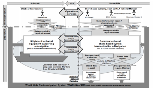
Innovation is an integral part of e-Navigation and the concept can only be successful if it balances a need for innovation with that for ensuring the quality and usability of any change in technology or processes. Constant innovation will also change how performance standards are handled. It is widely understood that the current ECDIS performance standard is restricting innovation, as its updating and certification concept is not geared to meet the needs of e-Navigation. This is now being addressed in the IMO's adoption of the IHO S-100 hydrographic data model as the basis for the Common Maritime Data Structure (CMDS) in e-Navigation.
Understanding complexity
Increasing complexity and interrelatedness is another mega-trend the world is facing. In order to carry out essential tasks, we have to quickly familiarize ourselves with new surroundings, circumstances and facts. To do that, we need swift and easy access to more information.
For a mariner, this can be gathering digital chart, weather, piracy and ship performance data in order to re-route a ship faced by a hurricane or other circumstances. For a ship in a clogged shipping lane encountering a newly built wind farm, it may be collecting navigational data such as Virtual Aids to Navigation (AtoN) and Automatic Identification System (AIS) to maintain the necessary situational awareness.
Embracing collaboration
Maritime authorities are realizing that they need to adapt to the speed of change as well as to cope with the growing complexity of today's society. With e-Navigation the maritime community is attempting to master this situation. The working groups and committees of inter-governmental organizations like the IMO and IHO are increasingly involving non-governmental organizations like IALA and CIRM as well as industry partners, well aware that they are more versed than public bodies in handling innovation and managing change. A growing number of maritime companies are participating in public-private cooperation and new multi-party alliances, sharing their innovation skills and adaptability experience in order to help migrate the industry towards the "shift age" and address the demands of today's changing maritime reality.
Integrated data: the e-Navigation backbone
As e-Navigation starts to gain traction in various organizations and the concept develops, the importance of integrated data, both static and dynamic, becomes increasingly apparent. The IALA and IHO, supported by CIRM have proposed the IHO GI Register (or S-100 Register) as the conceptual basis for the Common Maritime Data Structure (CMDS). Utilizing this common understanding of key players in the e-Navigation arena, the IMO e-Navigation Correspondence Group has firmed up the overarching architecture, enabling a series of test beds aimed at verifying the integration of various data streams to enable improved communication between stakeholders on shore or at sea.
The integration of pre-composed, expert-generated navigational data with real time and semi real-time data like Virtual AtoNs, Tide Gages Data or MSI transmission from VTS into a single e-Navigation display, if correctly developed, implemented and executed, will enable increased situational awareness for both mariners and shoreside staff.
The new e-Navigation framework aims to integrate and harmonize a growing number of data streams to create the information vital to increase situational awareness. This is changing the way systems are managed, type approved and more importantly how they handle and render chart data.
Hydrography and cartography
The e-Navigation scenario will also change how hydrography and cartography interrelate. While the changes in the regulatory framework will need to be developed over time in the IMO, the trend is towards a concept defining the conditions and regulatory requirements while allowing for innovation by avoiding over-specification.
The basis for chart products is currently generated by HOs or associated organizations that conduct surveys to provide bathymetric data layers. Together with information about navigational aids they create the foundation for navigational data. These basic data sets are enriched by information on navigation-related objects as well as procedural and regulatory information needed for a safe passage provided by organizations such as coastal administrations or port masters.
Cartographers then combine this static data to create a chart or publication. They also verify that the data sets do not conflict and compose them for ease of use. The resulting charts and publications are stand-alone products with no interoperability.
This method was also adopted in the chart-centric paradigm of ECDIS and ENCs. HOs prepare pre-composed ENCs of certain scale bands, which have an intended use and appropriate zoom factors, there by defining the look and feel as well as the appropriate rendering of ENCs in a type-approved ECDIS. Any "value-added data" may form an "overlay" but cannot really integrate with the ENC data.
Today, both static and dynamic data sets are available, but the different data streams may not be integrated as they may come from different sources. Therefore more data does not always result in better information and improved knowledge. It also carries a risk of "data overload." To solve this, the different data streams must be integrated and prepared for use to ensure they reach the mariner as meaningful information. For example, real-time water level information must be combined with static shore information, and static navigational aid information must be combined with AIS AtoN information. In this way, the various data streams will be integrated as a "nautical data collection." Updating of these integrated data streams must also be synchronized to avoid conflicts from misalignment of the various components.
A smart future
The ongoing development of electronic cartography in the maritime world has taken a step towards situational awareness and evolved away from simple chart display. This development will intensify and require a change in how digital maritime information is developed, composed and stored. The future demands integrated static and dynamic data streams that support data integration and situational centric rendering.
With this development, a mariner or fleet manager will get the information necessary to ensure a safe and efficient voyage whenever and however it's needed. While all of this is already technically possible and well underway, e-Navigation needs to be supported by a regulatory change from a framework defining detailed implementation aspects to one defining the "What" while allowing innovation to specify the "How" based on state-of-the-art and ever-evolving technology.